Rainfall and temperature time series (from 1981) reconstructed from station observations
and remote sensing proxies. This interface allows users to view rainfall, maximum
and minimum temperature climatologies and anomalies.
Rainfall and temperature time series (from 1981) reconstructed from station observations
and remote sensing proxies. This interface allows users to view rainfall, maximum
and minimum temperature climatologies and anomalies.
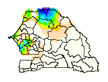
This page displays dekadal (approximately 10-day) rainfall amounts over the country.
The default map shows rainfall totals for the most recently available dekad, but totals
for previous dekads can be displayed as well.
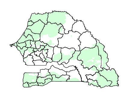
This map shows the historical probability of seasonal average rainfall falling within
the upper (wet), middle (normal), or bottom (dry) one-third ("tercile") of the 1981-current
historical distribution in Senegal given the state of ENSO (El Niño, Neutral, La Niña)
during that same season.
This map shows the historical probability of seasonal average temperature falling
within the upper (hot), middle (normal), or bottom (cold) one-third ("tercile") of
the 1981-current historical distribution in Senegal given the state of ENSO (El Niño,
Neutral, La Niña) duringthat same season.


/last/RANGE/T2/30.0/12.0/mul/runningAverage/T2/12.0/5.0/mul/STEP/%5BT2%5DregridLB/nip/T2/12/pad1/T/unsplitstreamgrid/sub/%7BY/cosd%7D%5BX/Y%5Dweighted-average/T/3/1.0/runningAverage/%7BLaNina/-0.5/Neutral/0.5/ElNino%7Dclassify/T/-2/1/2/shiftdata/%5BT_lag%5Dsum/5/flagge/T/-2/1/2/shiftdata/%5BT_lag%5Dsum/1.0/flagge/dup/a%3A/sst/(LaNina)/VALUE/%3Aa%3A/sst/(ElNino)/VALUE/%3Aa/add/1/maskge/dataflag/1/index/2/flagge/add/sst/(phil)/unitmatrix/sst_out/(Neutral)/VALUE/mul/exch/sst/(phil2)/unitmatrix/sst_out/(LaNina)/(ElNino)/VALUES/%5Bsst_out%5Dsum/mul/add/1/masklt/mul/%5BT%5Daverage/tercileclassesscale/rfe//Tercile/renameGRID/sst//ENSO/renameGRID/DATA/0/1/RANGE//name//proba/def//long_name/%28probability%29/def//fullname//proba/def/a-/-a/ENSO/%28LaNina%29//ensoState/parameter/VALUE/Tercile/%28Dry%29//tercile/parameter/VALUE/SOURCES/.WORLDBATH/.bath/X/-17.5875/-11.2125/RANGE/Y/12.225/16.8/RANGE/1/index/SOURCES/.Features/.Political/.Senegal_Adm/a%3A/.Commune/.the_geom/%3Aa%3A/.Arrondissement/.the_geom/%3Aa%3A/.Department/.the_geom/%3Aa%3A/.Region/.the_geom/%3Aa/X/Y/fig-/colors/colors/||/colors/grey/verythin/solid/stroke/thin/stroke/black/stroke/thinnish/stroke/-fig//antialias/true/psdef//T/%28Jul-Sep%29/plotvalue//plotbordertop/60/psdef//plotborderbottom/53/psdef//plotaxislength/450/psdef//fntsze/15.0/psdef//layers%5B//proba//Department//Region%5Dpsdef//plotborder/0/psdef//color_smoothing/1/psdef/+.gif)
/last/RANGE/T2/30.0/12.0/mul/runningAverage/T2/12.0/5.0/mul/STEP/%5BT2%5DregridLB/nip/T2/12/pad1/T/unsplitstreamgrid/sub/%7BY/cosd%7D%5BX/Y%5Dweighted-average/T/3/1.0/runningAverage/%7BLaNina/-0.5/Neutral/0.5/ElNino%7Dclassify/T/-2/1/2/shiftdata/%5BT_lag%5Dsum/5/flagge/T/-2/1/2/shiftdata/%5BT_lag%5Dsum/1.0/flagge/dup/a%3A/sst/(LaNina)/VALUE/%3Aa%3A/sst/(ElNino)/VALUE/%3Aa/add/1/maskge/dataflag/1/index/2/flagge/add/sst/(phil)/unitmatrix/sst_out/(Neutral)/VALUE/mul/exch/sst/(phil2)/unitmatrix/sst_out/(LaNina)/(ElNino)/VALUES/%5Bsst_out%5Dsum/mul/add/1/masklt/mul/%5BT%5Daverage/tercileclassesscale//var/get_parameter/1/4/getinterval/interp//Tercile/renameGRID/sst//ENSO/renameGRID/DATA/0/1/RANGE//name//proba/def//long_name/%28probability%29/def//fullname//proba/def/a-/-a/ENSO/%28LaNina%29//ensoState/parameter/VALUE/Tercile/%28Cold%29//tercile/parameter/VALUE/SOURCES/.WORLDBATH/.bath/X/-17.5875/-11.2125/RANGE/Y/12.225/16.8/RANGE/1/index/SOURCES/.Features/.Political/.Senegal_Adm/a%3A/.Commune/.the_geom/%3Aa%3A/.Arrondissement/.the_geom/%3Aa%3A/.Department/.the_geom/%3Aa%3A/.Region/.the_geom/%3Aa/X/Y/fig-/colors/colors/||/colors/grey/verythin/solid/stroke/thin/stroke/black/stroke/thinnish/stroke/-fig//antialias/true/psdef//T/%28Jul-Sep%29/plotvalue//plotbordertop/60/psdef//plotborderbottom/53/psdef//plotaxislength/450/psdef//fntsze/15.0/psdef//layers%5B//proba//Department//Region%5Dpsdef//plotborder/0/psdef//color_smoothing/1/psdef/+.gif)